
Súbor:Rs-map.png
Nie je dostupné vyššie rozlíšenie.
Rs-map.png (634 × 323 pixelov, veľkosť súboru: 37 KB, MIME typ: image/png)
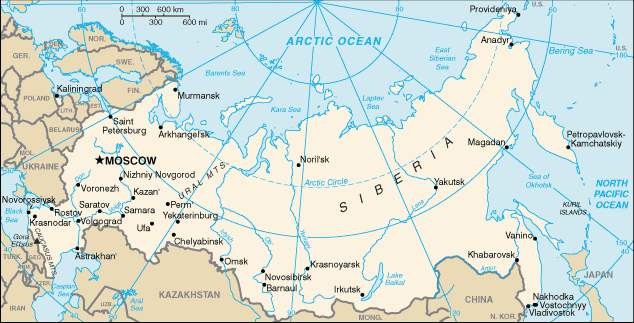
CIA map of Russia. https://www.cia.gov/library/publications/the-world-factbook/geos/rs.html archive copy at the Wayback Machine
This version of CIA World Factbook map has few changes compared to the previous version at Commons.
See also SVG version: Image:Blank map of Russia-geoloc.svg
Tento obrázek je volné dílo, jelikož obsahuje materiál původně pocházející z publikace The World Factbook vytvářené Ústřední zpravodajskou službou Spojených států amerických.
|
 |
.jpg)
| Annotations | This image is annotated: View the annotations at Commons |
História súboru
Po kliknutí na dátum/čas uvidíte ako súbor vyzeral vtedy.
| Dátum/Čas | Náhľad | Rozmery | Používateľ | Komentár | |
|---|---|---|---|---|---|
| aktuálna | 16:40, 16. máj 2009 | | 634 × 323 (37 KB) | Pasixxxx | New version of this map from CIA World Factbook site. Few more cities, Yekaterinburg location has changed considerably compared to the Commons' previous version. From CIA World Factbook site [https://www.cia.gov/library/publications/the-world-factbook/geo |
| 15:50, 3. december 2004 |  | 635 × 324 (29 KB) | Kneiphof | CIA map of Russia, PD |
Použitie súboru
Na tento súbor odkazuje nasledujúca stránka:
Globálne využitie súborov
Nasledovné ďalšie wiki používajú tento súbor:
- Použitie na als.wikipedia.org
- Použitie na ar.wikipedia.org
- Použitie na ast.wikipedia.org
- Použitie na az.wiktionary.org
- Použitie na ceb.wikipedia.org
- Použitie na cs.wikipedia.org
- Použitie na de.wikipedia.org
- Použitie na diq.wikipedia.org
- Použitie na dsb.wikipedia.org
- Použitie na en.wikipedia.org
- Wikipedia:In the news/Candidates/December 2005
- List of twin towns and sister cities in Russia
- Wikipedia:Reference desk/Archives/Science/2007 July 18
- Northern river reversal
- Energy in Russia
- User:Epipelagic/sandbox/ref3
- Module talk:Location map/Archive 1
- User:Andrewjlockley/Hydraulic geoengineering2g
- User:Morriswa/My OCONUS travel
- Wikipedia:In the news/Posted/December 2005
- User:Falcaorib/Russia and Soviet Union
- Použitie na en.wikibooks.org
- Použitie na en.wiktionary.org
- Použitie na es.wikipedia.org
- Použitie na fr.wikipedia.org
- Použitie na gl.wikipedia.org
- Použitie na he.wikipedia.org
- Použitie na hif.wikipedia.org
- Použitie na hu.wikipedia.org
Zobraziť ďalšie globálne použitie tohto súboru.