
Súbor:Ethnic Map of Hungary 1910 with Counties.png

Veľkosť tohto náhľadu: 800 × 529 pixelov. Iné rozlíšenia: 320 × 212 pixelov | 640 × 423 pixelov | 1 024 × 677 pixelov | 1 280 × 846 pixelov | 2 560 × 1 692 pixelov | 6 208 × 4 104 pixelov .
Pôvodný súbor (6 208 × 4 104 pixelov, veľkosť súboru: 1,41 MB, MIME typ: image/png)
Zhrnutie
| Popis |
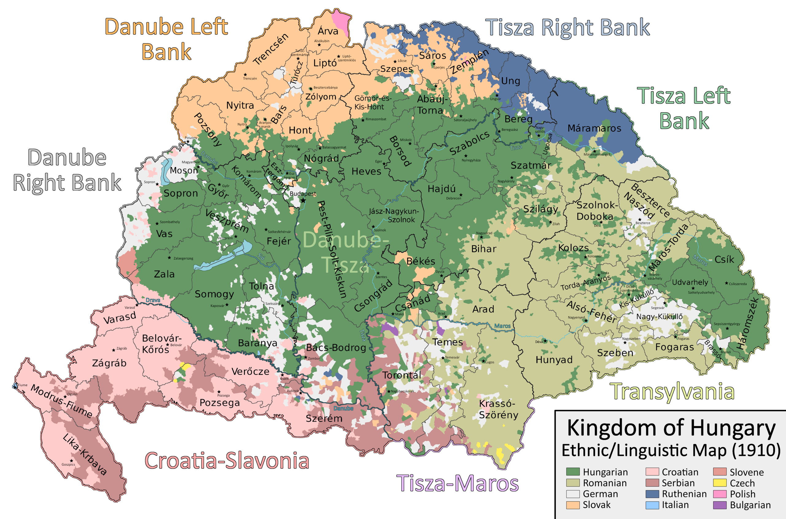
English: A map which shows the counties and larger regional subdivisions of the Kingdom of Hungary according to the 1910 census, with majority/plurality ethnicities indicated by color |
| Dátum | |
| Zdroj | Vlastné dielo |
| Autor | Ascended Dreamer |
Licencovanie
Ja, držiteľ autorských práv k tomuto dielu ho týmto zverejňujem za podmienok nasledovnej licencie:
Tento soubor podléhá licenci Creative Commons Uveďte autora-Zachovejte licenci 4.0 International
- Môžete slobodne:
- zdieľať – kopírovať, šíriť a prenášať dielo
- meniť ho – upravovať dielo
- Za nasledovných podmienok:
- uvedenie autorov – Musíte spomenúť autorov (jednotlivo alebo kolektívne), poskytnúť odkaz na licenciu a uviesť, či ste niečo zmenili. Môžete to urobiť ľubovoľným primeraným spôsobom, ale nie spôsobom naznačujúcim, že poskytovateľ licencie podporuje vás alebo vaše použitie diela.
- meniť za rovnakých podmienok – Ak toto dielo zmeníte, prevediete do inej formy alebo použijete ako základ iného diela, musíte výsledok šíriť pod rovnakou alebo kompatibilnou licenciou ako originál.
História súboru
Po kliknutí na dátum/čas uvidíte ako súbor vyzeral vtedy.
| Dátum/Čas | Náhľad | Rozmery | Používateľ | Komentár | |
|---|---|---|---|---|---|
| aktuálna | 13:29, 22. september 2023 | | 6 208 × 4 104 (1,41 MB) | Ascended Dreamer | Change color of Slovene |
| 15:00, 22. júl 2023 |  | 6 208 × 4 104 (1,41 MB) | Ascended Dreamer | Correcting more errors noticed by Alphathon | |
| 21:26, 19. júl 2023 |  | 6 208 × 4 104 (1,41 MB) | Ascended Dreamer | Incorporating Corrections made by Alpathon | |
| 08:40, 19. júl 2023 |  | 6 208 × 4 104 (1,34 MB) | Alphathon | Applied (rough) corrections to Bars/Hont and Csongrád/Bács-Bodrog borders | |
| 23:02, 1. júl 2023 |  | 6 208 × 4 104 (1,41 MB) | Ascended Dreamer | Corrected location of Nagykároly | |
| 20:02, 27. apríl 2023 |  | 6 208 × 4 104 (1,41 MB) | Ascended Dreamer | Corrected color indicating Slovenes | |
| 01:18, 21. január 2023 |  | 6 208 × 4 104 (1,41 MB) | Ascended Dreamer | Changed color of lakes to blue | |
| 22:33, 20. január 2023 |  | 6 208 × 4 104 (1,41 MB) | Ascended Dreamer | Increased border accuracy | |
| 03:26, 16. január 2023 |  | 6 208 × 4 104 (1,19 MB) | Ascended Dreamer | Added county capital names | |
| 20:44, 15. január 2023 |  | 6 208 × 4 104 (975 KB) | Ascended Dreamer | Cleaned up map, fixed error, added small stars indicating county capital locations. Better to leave them unlabeled? |
Použitie súboru
Na tento súbor odkazujú nasledujúce 2 stránky:
Globálne využitie súborov
Nasledovné ďalšie wiki používajú tento súbor:
- Použitie na ca.wikipedia.org
- Použitie na en.wikipedia.org
- Použitie na hu.wikipedia.org
- Použitie na pt.wikipedia.org
- Použitie na sr.wikipedia.org
- Použitie na tr.wikipedia.org